


Appendices
24 Test Bed Receiver Subsystem Addendum – Rev 1
The NovAtel MiLLennium-GLONASS GPSCards can be applied in mining and machine control, robotics, flight
inspection, marine navigation, agriculture, military, direction finding and other custom OEM applications.
Some of the information used to create the Introduction was obtained from two sources.
1. Langley, Richard B. “GLONASS: Review and Update”. GPS World
, July 1997. 46-51
2. Kleusberg, Alfred. “Comparing GPS and GLONASS”. GPS World
, December 1990. 52-54
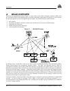
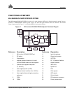
GLONASS SYSTEM DESIGN
As with GPS, the GLONASS system uses a satellite constellation to ideally provide a GLONASS receiver with six to
twelve satellites at most times. A minimum of four satellites in view allows a GLONASS receiver to compute its
position in three dimensions, as well as become synchronized to the system time.
The GLONASS system design consists of three parts:
• The Space segment
• The Control segment
• The User segment
All these parts operate together to provide accurate three-dimensional positioning, timing and velocity data to users
worldwide.
The Space Segment
The Space Segment is the portion of the GLONASS system that is located in space, that is, the GLONASS satellites and
any ancillary spacecraft that provide GLONASS augmentation information (i.e., differential corrections, integrity
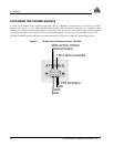
messages, etc.). This segment is composed of the GLONASS satellites which, when complete, will consist of 24
satellites in three orbital planes, with eight satellites per plane, see Figure 14, Page 25. Following are points about the
GLONASS space segment.
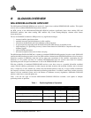
• The orbit period of each satellite is approximately 8/17 of a sidereal day such that, after eight
sidereal days, the GLONASS satellites have completed exactly 17 orbital revolutions. A sidereal
day is the rotation period of the earth and is equal to one calendar day minus four minutes.
• Because each orbital plane contains eight equally spaced satellites, one of the satellites will be at the
same spot in the sky at the same sidereal time each day.
• The satellites are placed into nominally circular orbits with target inclinations of 64.8 degrees and
an orbital height of about 19,123 km, which is about 1,060 km lower than GPS satellites.
• The GLONASS satellite signal identifies the satellite and provides:
o
the positioning, velocity and acceleration vectors at a reference epoch for computing satellite locations
o synchronization bits
o data age
o satellite health
o offset of GLONASS time
o almanacs of all other GLONASS satellites.
• The GLONASS satellites each transmit on different L1 and L2 frequencies, with the P code on both
L1 and L2, and with the C/A code, at present, only on L1. L1 is currently centered at 1602 - 1615.5
MHz.
• Some of the GLONASS transmissions initially caused interference to radio astronomers and mobile
communication service providers. The Russians consequently agreed to reduce the number of