Creating a Layer from a DWF File Sheet | 29
Creating a Layer from a DWF File Sheet
DWFs are really intended to be used as background images, in much the same
way that DWG files were used in previous releases. Because DWFs are essen-
tially electronic plots, the level of precision depends on the plot settings. This
is not an issue for most maps. However, if your application demands a higher
degree of precision,
you can increase the size of the virtual DWF paper by
setting the appropriate DPI and paper size before you publish to DWF.
The following link goes to an article that explains DWF precision, why it is
not the same as the DWG, and how to improve the precision.
http://autodesk.blogs.com/between_the_lines/2004/01/
dwf_precision_a.html
As you could with a DWG layer, you can bring in specific layers from the
DWF file. However, you cannot stylize or theme the features once they are
part of the map. Also, font information is stored in the DWF and cannot be
changed.
Note By default, a DWF file created in Autodesk Map does not retain the layers
from the original DWG file. If you want to bring in specific layers from the DWF
file, you must modify the DWF plot-configuration file. For more information, see
the topic “Overview of Creating or Modifying a DWF6 Configuration File” in the
AutoCAD Help.
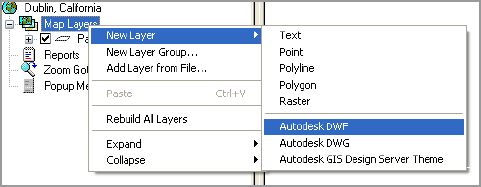
To create a new Autodesk MapGuide Author layer from a DWF file
1 In Autodesk MapGuide Author, right-click Map Layers, and then click
New Layer
➤ Autodesk DWF.
2 On the General tab, enter a name for the new layer.
Note If you use a high-dpi DWF for a DWF layer, and you select the Make
Map Features Selectable check box (on the General tab of the Map Layer Prop-
erties dialog box), it may take a long time to select all the map features.
3 Click the Data Sources tab, and make sure that the Map agent path is
pointing to the correct location.


